The first time I went to St Helens Oregon was in a boat!
We put our motor boat in at Sauvie Island and decided to explore the Columbia Slough. We had been up and down the Willamette and Columbia, but never the Slough. As soon as we entered it, it was like entering a peaceful magical land full of water and nature, forests and meadows and sky! No people, no boats. We cruised for quite a while, every once stopping at a beach or an old dock, then for lunch at a dockside restaurant…way out in the wilderness! Finally we came into an urban area, with a town that tumbled up the hill to the south and a deserted Island to the north. This was St Helens. We stopped in the little town, walking up the steep streets that led up from the river, looking 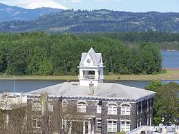 back to a beautiful view showing the slough, and the Columbia behind it, and the top of the Island that had created the Columbia Slough, Sauvie Island. I never knew it was so long! We always accessed it from Portland, just after the St John’s Bridge, in fact that was where we had put our boat in the water. Then we crossed to the island to explore it. It was very narrow here, and on the other side was the mighty Columbia! I was enthralled, and we have taken the trip several times since!
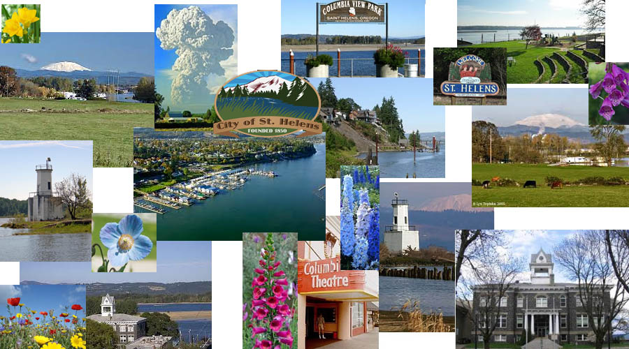
St Helens Oregon is the county seat of Columbia County, Oregon and it was founded way back in 1845, which is why it has so many cool historic buildings. In it’s heyday it really must have been something! It was founded by Captain H. M. Knighton, a native of New England in 1845 and was called Plymouth, after his home port. The name of the community was changed to St. Helens, in the latter part of 1850, after the view of Mount St. 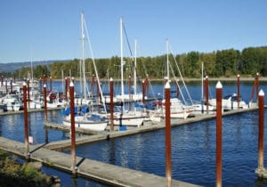 Helens across the Columbia River in Washington. I talk more about the history of this area in the history section below. St. Helens is a deep-water seaport, and is eighteen miles upstream from Rainier, Oregon, and just downstream of where the Multnomah Channel merges into the Columbia River. The community lies within the Scappoose Bay watershed. Downstream is Deer Island, the small community of Goble, Prescott Beach, and the location of the former Trojan Nuclear Facility. Upstream is Sauvie Island. Across the river on the Washington
 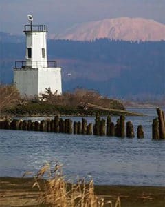 side the mouth of the Lewis River enters the Columbia a mile upstream. Lewis and Clark passed through the area in 1805 and referred to the rocky cliffs on which would eventually border the town of St. Helens.
St Helens Oregon is located in southeastern Columbia County, on the Columbia River, approximately 30 miles northwest of Portland, Oregon. There are many City Parks in Saint Helens. Near the riverfront, the Old Town portion of St. Helens has a Nationally Registered Historic District encompassing 10 blocks, which is what I saw when I first came up the stairs from the river. I felt like I was in a quaint little historic town with lots of charm. The buildings date back nearly a century.The original settlers were loggers from New England, but St Helens Oregon, also has a huge basalt rock quarry, which was also one of the early industries. Today jobs include forest products, mining, and manufacturing operations.
Warrior Rock Lighthouse: is right at the tip of Sauvie Island, where the Columbia Slough flows into the Columbia River.
History of St Helens Oregon
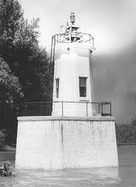 Early History of the Warrior Rock Light House: In 1792, an exploratory party from Captain Vancouver’s Columbia River expedition, stopped at the rocky point at the end of Sauvie Island. They were quickly surrounded by 23 canoes of Chinook Indians, ready for war! The captain decided it was better to make peace, they agreed, and the Rock got it’s name of Warrior Rock. A century later, the US government decided to put a lighthouse there because there was so much river traffic, and there could be fog at times. It was finally built in 1889 and was originally a small two story structure on a sandstone foundation. The single room first floor was the keeper’s quarters, the second floor was mostly a covered half deck housing the lens lantern and fog bell. Later a house and barn were added. The bell is the oldest fog bell in the Pacific Northwest. It was cast in Philadelphia in 1855, and first used at Cape Disappointment at the mouth of the Columbia River. The winds, land contour, and roaring seas made it hard to hear the bell, so the bell was replaced and moved to the West Point Lighthouse in Puget Sound, and then it found it’s final home here at Warrior Rock in 1889.
In 1912, the light house service bought 1.6 acres of land, with a house and barn. Before that, the light 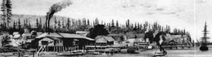 keeper had to sleep in the lower room. The area gets lots of wind and fog, and one of the light-keepers who served in the 1920s, nicknamed the bell “Black Moria” because the bells striking mechanism broke so often, he would have to ring it manually…sometimes for hours. It seems like the lighthouse was really needed because during it’s first season it tolled every 15 seconds for 316 hours, and the lamp kept blowing out!
In 1939 an interesting thing happened. The Columbia and Willamette Rivers below Portland froze over for the first time in sixty years. Several island communities in the lower Columbia were cut off by the ice, and the people and livestock had no food or other provisions. The lighthouse tender Rose was loaded up with supplies for the settlements and made seven landings, delivering ninety tons of supplies and feed. The keeper walked across on the smooth ice for several days until a tank steamer broke the ice.
 St Helens Oregon was became a river port on the Columbia River in the 1840s, being a deep-water port that even surpassed Portland…. until the docks burned down twice…under very mysterious conditions. Portland then became the main port, and St Helens just a small town along the Columbia. It was first names Plymouth by it’s founder, Henry M. Knighton, who was a sea captain from New England who came to the area in 1845. It was renamed “St. Helens” in 1850 because of the gorgeous view of Mt St Helens across the water.
The very first person to really settle in St Helens Oregon was Mr Knighton, in 1845. He was kind of a partier, 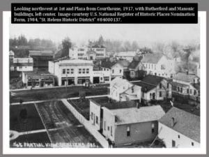 so his personality kind of drew people to the area. In 1847 he lived on his donation Land Claim, which had 2 log homes on it at that time. He lived in one, and used the other as sort of a hotel. He had a few lots surveyed off his property a couple of years later, but didn’t do much with them until the road opened that came down the hill from the Tualatin Mountains- it had been an old Indian trail, but was improved in around 1850. This made it easy for people to come into the area, there was
 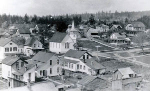 coal, iron ore, lots of timber, and a gorgeous location on the river. The town of St Helens Oregon grew quickly, as you can see when you walk up the hill from the river, into town. There are many beautiful old buildings showing a prosperous past.
Pacific Mail Steamship company ran up and down the river, and in 1852 a warehouse and wharf were built in St Helens Oregon. The captains of the ships would much rather drop things off in St Helens because it had a deep water port, and Portland had sand bars like the Swan Island bar, which made it difficult to get 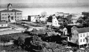 into the Port. St Helens was becoming the main Port, Portland was getting upset, because they were losing business, and suddenly there were 2 mysterious fires that destroyed the wharf and all the improvements that had been made.
 Portland took over, and became the main port. In 1865 Mr Victor bought the area, hoping to bring back business, but it was too far from Portland, and not enough people lived there, so it never reached it’s potential greatness. It had been named the county seat in 1857, and it became a factory, mill, lumber town, with agriculture on the side!
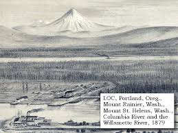
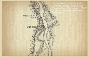
This is the original Lewis and Clark map showing St Helens, so Lewis and Clark actually discovered this town way back in the early 1800s
Parks in St Helens Oregon
Campbell Park: Includes two picnic shelters with charcoal cookers, a playground, 2 ball fields, concession stands, 4 tennis courts, 1 cemented and fenced activity area and restrooms.
Civic Pride Park: Includes a picnic shelter with charcoal cookers, playground and a restroom.
Columbia Botanical Gardens: Includes a nature trail.
Columbia View Park: Columbia River frontage with a Gazebo that has Electricity. The park also includes a playground, handicapped-access viewing platform, commemorative brick courtyard, picnic tables, restrooms with showers and floral plantings.
Godfrey Park: Includes a picnic shelter with charcoal cookers, playground, horseshoe court and chemical toilet.
Heinie Heumann Park:Includes picnic tables, playground and chemical toilet.
Highway 30 Greenway:This is a 5.3 acre strip, 35 feet wide and has a landscaped area. There are pathways and benches.
Little League Park: Includes 2 multi-purpose athletic fields with dugouts, seating and removable goalposts. Restrooms and 2 concession stands.
McCormick Park:Milton Creek runs through the park. The Park includes 2 softball fields, restrooms with showers and concession stands, a sand volleyball court, skateboard park, playground, picnic areas, fitness trail that is 1.5 mils with exercise stations and nature trails. It also has a Japanese Garden and landscaped areas, a Veterans Memorial and overnight camping.
Sand Island Marine Park:This Park is a manmade Island in the Columbia River with concrete docks, access ramp, picnic shelter, 37 overnight campsites, restrooms, nature trails, swimming/sunbathing beaches and volleyball anchor posts.


")


