We go by the cutoff to Vernonia Oregon every time we drive to Cannon Beach along 26, and to get to it from there, you have to drive through deep forest and mountains…the beginning of the coast range.
I’ve been to Vernonia Oregon a few times, love the beautiful forest, the Nehalem River and would love to take my bike and go on the Banks Vernonia Trail. Vernonia Oregon is at the cross roads of the Nehalem River and Rock Creek, which flooded several years ago. Quite a bit of the town was under water, and it took quite a while for everyone to recover. Vernonia Lake and 2 small ponds sit in the curve of the 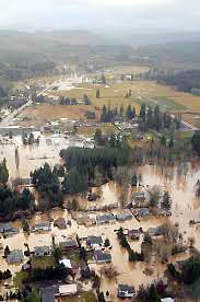 Nehalem River, where Rock Creek comes in, and several other creeks. It must have just been too much rain for the rivers
 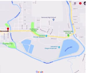 to handle.
The City of Vernonia Oregon is located in the beautiful North West coast mountain range of Oregon, in Columbia County. It is centrally located between the Oregon Coast and Portland Oregon and approximately 35 miles south of the Columbia River, it is just a little north of the Tillamook State Forest, and east of the Clatsop State Forest; and 44 miles NW of Portland. It is between the Willamette Valley and the Columbia River, which is north.
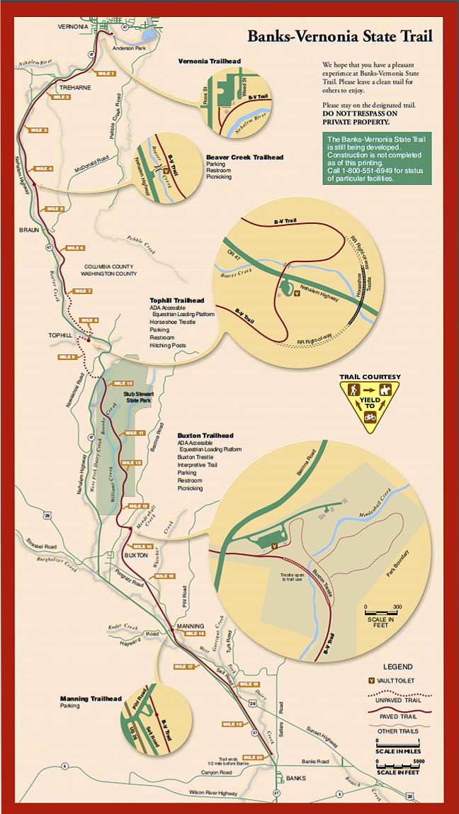
Growing up as a logging community in the scenic Nehalem River Valley, the town has retained much of its turn of the century charm and has become an inviting place to live. Logging is still an important part of the region and there are many managed forests and mountain streams to explore. There are many logging trails and scenic viewpoints that reveal the beauty of the Pacific Northwest. The Banks Vernonia Trail is the biggest, which goes for 21 miles along an old train bed. This is a pretty amazing trail. I love where I live because of the Fanno Creek Trail, but this one is mostly paved, goes through the forest, 21 miles of tree-lined, easy-grade pathway conducts you through sun-dappled glades and across swift, clear streams, filling your nose with wildflower scents and your ears with the songs of birds. 13 old bridges, wooden trestles rise up to acquaint you with days of the past. (that last description was taken from the Oregon State Park Website) You can read more about it below under parks and trails. There are also several lakes, as shown in the map above, the biggest being Vernonia lake.
In the last decade Vernonia has under gone quite a face-lift through the leadership of the City and the help of many volunteers. The revitalized downtown, the extensive park system (including a public summer swimming hole and a full-service RV park), the new City Hall and Library buildings, the Banks-Vernonia Linear Park trail, Vernonia Lake (a very popular fishing spot), the beautiful Scout Cabin, and the Vernonia Pioneer Museum have all instilled Vernonia with b sense of community pride. The upcoming additions of a middle school facility, Learning Center, new Senior Center and the burgeoning Art Community will further contribute to an even better quality of life for all.
Parks and Natural areas in Vernonia Oregon
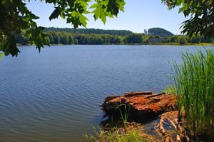 Vernonia Lake or Pond is a 45 acre man made reservoir right on the edge of Vernonia Oregon. There is a trail going all around the lake with two fishing docks, a platform area and a gradual grade so you can walk down to the water. It is set up for kids and people with disabilities. You can launch a boat too, either kayak, canoe, or floaties, no motor boats. It is stocked with lots of fish, mostly rainbow trout. They also have large mouth bass, crappie and sometimes steelhead. The fish bite especially in spring because they have been raised in a farm, and once they get out into the open water, they bite like crazy! Good place to teach your kids to fish.
The Banks-Vernonia Trail, is a multi-use trail paved over a decades-old train bed, allows the 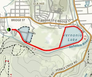 walker, jogger, biker or mounted rider the chance to catch a whiff of Oregon history while delighting in the forest’s renewed splendor. Walk, bicycle, ride your horse or push a baby buggy along this nice, quiet trail along an old abandoned 21 mile railroad path. It is 21 miles of beautiful forested tree-lined, easy-grade pathway that takes you through sun-dappled glades and across swift, clear streams, filling your nose with wildflower scents and your ears with the songs of birds. 13 old bridges,
 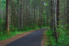 wooden trestles rise up to acquaint you with days of the past.
The Banks-Vernonia Trail can be accessed at any of 6 points along its progression – including trail heads at Manning, Buxton, Tophill, and Beaver Creek, as well as at Banks and Vernonia themselves – and permits only non-motorized use at a safe, slow speed. Precisely the opposite, ironically, of the trains that once ran there. Nature has a way of making things come full circle, a theory proved in lovely, pastoral abundance by a rail-to-trail like the BVT. Visit today and see just how much good those old railroads are still doing – for Oregon, for the forest itself and (especially) for you. You can see the map below.
Hawkins Park: In early summer a small dam across Rock Creek creates “Dewey Pool swimming area. There is also a concrete kiddy pool. There is a lifeguard on duty Monday-Saturday noon to 6pm.
Ora Bolmeier Park: Nestled among large fir trees this park overlooks downtown Vernonia.
Spencer Park: Includes fields for softball, baseball, soccer, or foot ball. It’s a great place for team sports.
Shay Park: The final resting place of Shay Locomotive #102 which was once owned and operated by the Oregon-American Lumber Company. There is a trail leading down to a viewing platform next to the creek for an up close view of the salmon in the river.
Vernonia Airport Park: A primitive campground tucked in old growth fir, maples, and alder trees along the Nehalem River, is a wonderful place to relax and enjoy nature.
Anderson Park: The trail-head for the Banks-Vernonia trail. This park is bordered by the Rock Creek and the Nehalem River.
History of Vernonia Oregon
History
The first settler in the Upper Nehalem Valley area was Clark Parker who chopped his way into the 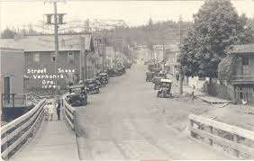 area and homesteaded in 1874. His Homestead was on the East side of the Nehalem River (Riverview). He came in from the Washington County side. He was followed in 1875 by the Van Blaricom’s who homesteaded along Rock Creek in what is now the main part of town.
The first road out of the upper valley to the North was opened with volunteer labor apparently in 1879. It reached the Nehalem Valley at Pittsburg which is located at the confluence of the Nehalem with the ‘East Fork’. It was a dirt wagon road and is known today as the ‘St. Helens-Pittsburg’. Hardship did not go away with the opening of the road however. In January of 1880 a violent windstorm closed all roads into the valley by toppling trees. The wind was followed by extraordinary snow and the area was reportedly isolated for months.
Weekly mail service between St. Helens and Vernonia began shortly after the road was opened and by 1891 was said to have grown to 3 times a week.
While it was June of 1894 that provided the ‘record’ flood on the Columbia River, it was the next year that was the challenge for Vernonia. Bunker Hill saw 5 feet of snow and in January of 1895 the first great flood swamped Vernonia to a level not surpassed until the great flood of February 8, 1996 over a century later.
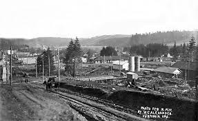 Vernonia’s heyday began in the 1920’s when it was the site of the Oregon-American Sawmill, billed at the time as the largest in the world, which was fed by logging railroads in all directions, but by the early 1950’s the virgin timber was gone and so was the mill. The timber has grown back, but there is no mill in Vernonia now. The company came in from the South and brought a lot of Southern folks with them. This explains why the plat of the Oregon-American Subdivision features streets named after States in the old Confederacy.
It is reported that some southern traditions also came to town which included the establishment of a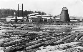 ‘black section’ of town which was down by the river behind what is now the Vernonia High School. The mill is said to have kept this part of the mill town ‘segregated’ by not allowing any of the buildings in that area to be painted or whitewashed. This area is all long gone now.
Vernonia Oregon was ultimately named for the daughter of one of the original settlers, Ozias Cherrington who moved there in 1876. Her name was Vernonia. She was born March 30, 1868 in Ohio and later moved to Virginia. She never came to Oregon. The political voting precinct was called Auburn for many years, but finally renamed to Vernonia to avoid confusion. The Vernonia post office was established Jan 11, 1878 with David F. Baker as its first postmaster.


")


